Environmental Analysis of Mare Favela
Authors: Sylvia Lam, Madeline Morphis, David Aponte, Caleb Hassell
Maré is a favela located in Rio de Janeiro, Brazil. Our team conducted an environmental vulnerability analysis to assess the multifaceted challenges facing its residents. Leveraging open-source environmental and climatological datasets, we performed a raster-based spatial analysis using ArcGIS Pro to visualize the distribution of rainfall intensity and surface temperature across Brazil, with a focused assessment on Maré.
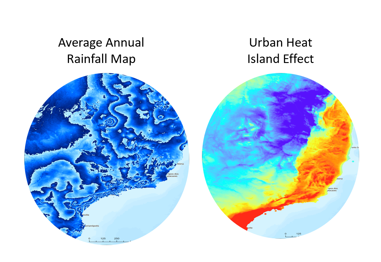
Our analysis was structured across three geographic scales: local, regional, and national, to contextualize both the micro-level living conditions and broader systemic factors influencing Maré.
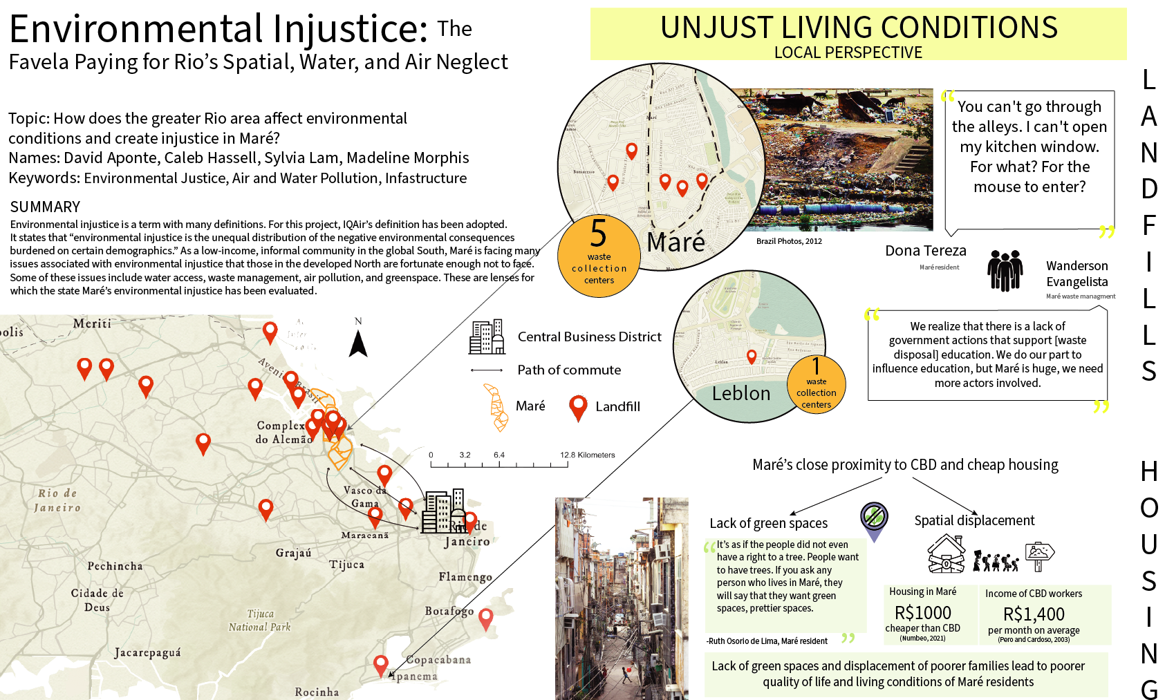
At the neighborhood scale, residents of Maré are exposed to degraded environmental conditions. Our spatial mapping highlighted the scarcity of green infrastructure and proximity to unmanaged landfill sites, which contribute to lower quality of life. The adjacency of residential zones to waste facilities has resulted in pervasive rodent infestations, hygiene concerns, and persistent odor issues. These are further compounded by the lack of public open spaces, restricting recreational areas and limiting opportunities for social interaction and physical activity.
Additionally, Maré is undergoing demographic and housing pressure due to its relatively lower housing costs. As employment opportunities in central Rio attract low-wage workers, Maré becomes a destination for affordable housing, creating spatial displacement and socioeconomic tension for long-term residents. These evolving pressures underscore the need for responsive urban policy and inclusive spatial planning interventions.
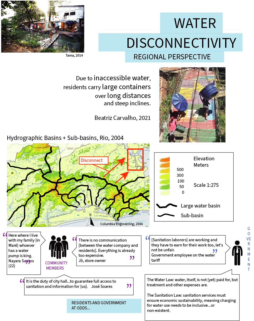
On a regional level, we identified critical issues related to water infrastructure disconnectivity. The hydrological analysis revealed that water sources are located at significant distances from the settlement, placing an undue burden on residents who must travel long distances for water collection. This infrastructure gap reflects a broader governance issue in which state-led service provision remains inadequate, failing to ensure equitable, reliable, and affordable water access.
This situation illustrates the fragmentation of urban service delivery and the disconnect between government agencies and informal communities, a recurring challenge in peripheral urban settlements.
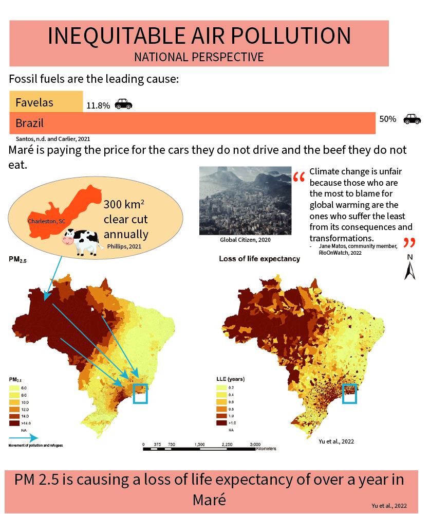
National-scale environmental stressors also influence life in Maré. Through atmospheric data analysis, we examined how transboundary air pollution, particularly from deforestation and biomass burning in the Amazon, contributes to declining air quality in Rio de Janeiro. The resulting exposure to fine particulate matter (PM2.5) has led to respiratory illnesses and heat-related health risks among Maré’s population.
Ironically, the residents of Maré contribute minimally to national greenhouse gas emissions yet bear a disproportionate share of its environmental consequences. This dynamic reflects issues of climate injustice and underscores the need for national climate adaptation policies that are responsive to vulnerable urban populations.
To ensure the inclusion of community perspectives, our final presentation incorporated qualitative narratives from residents of Maré. Two citizens currently pursuing studies at Virginia Tech participated in our stakeholder feedback session. They provided valuable insights on the challenges of internal mobility, particularly regarding the physical layout of Maré.
The neighborhood is characterized by narrow, unpaved streets with insufficient maintenance. As a result, transportation options are restricted primarily to motorcycles and bicycles. These conditions hinder formal service delivery such as postal services and ride-hailing services. Residents living deeper within Maré are often unable to receive Uber or delivery services at their homes and must walk from the periphery. This has contributed to addressing inconsistencies, urban informality, and logistical challenges in basic infrastructure access.
Our project applied a combination of geospatial analytics, qualitative research, and multi-scalar environmental assessment to understand the interconnected vulnerabilities in Maré. The findings emphasize the importance of integrated planning strategies that account for environmental justice, infrastructure equity, and the lived experiences of marginalized urban communities.
The project demonstrates how spatial data science can inform inclusive urban resilience planning, especially in areas traditionally excluded from formal urban policy frameworks.